Why is the Black Sea called the Black Sea

The ancient Greeks were the first to name the Black Sea, and they called it "Inhospitable Sea", since the sea was difficult to navigate, and also at the time, hostile tribes inhabited its shores. With the settlement of Greek colonists at the shore of the sea, its name became “Eύξεινος Πόντος”, or "Hospitable Sea". This name is still used in some Greek sources, but also the name “Μαύρη Θάλασσα” or "Black Sea" is common in many sources.

Black Sea Bulgaria

Photo: Pixabey...

It has not been established exactly to which of the explanations the name of the Black Sea can be traced back, but is certain that the name comes from the Turkish vocabulary. 

When Anatolia was conquered by the Ottomans, they kept the names used by the Genoese and Venetians. They called the Black Sea the "Mare Maggiore", or the "Great Sea".

"Mare Maggiore" translated into the language of the Ottomans, means "KaraDeniz". Deniz stands for sea. The word Kara in Turkish has several meanings, like big, dark, and cloudy. Over the years the meaning of the word "kara" changed into the word "dark" or Black, and Slavic people like the Bulgarians and Russians kept this expression.

But why the sea is called - Black

The water of the Black Sea is so opaque that it is almost impossible to see through more than 2 feet (60 cm) of the upper water layer. The sea is more than 150 meters deep and its water is filled with hydrogen sulphide, therefore, there are no living beings in the deepest layers of its water, except for sulphur bacteria. Metal objects from ships, dead plants and animal matter that had sunk over 150 meters deep for a long time were covered in black mud due to the high concentration of hydrogen sulphide in the sea.

From the point of view of seafarers, the sea has been black due to severe winter storms which make the water so dark it looks black.

What other names are used for the Black Sea?

Current names of the sea are usually equivalents of the English name "Black Sea", including these given in the countries bordering the sea: (Wikipedia.org...)

  • Abkhazian: Амшын Еиқәа, romanized: Amʂən Eikʰʷa
  • Adyghe: Хы шӏуцӏэ, romanized: Xı ṩʔutsʔə
  • Armenian: Սեւ ծով, romanized: Sev tsov
  • Bulgarian: Черно море, romanized: Cherno more
  • Crimean Tatar: Къара денъиз, romanized: Qara deñiz
  • Georgian: შავი ზღვა, shavi zghva
  • Laz and Mingrelian: უჩა ზუღა, romanized: Ucha Zugha, IPA: [utʃɑ zuɣɑ], or simply ზუღა
  • Romanian: Marea Neagră, pronounced [ˈmare̯a ˈne̯aɡrə]
  • Russian: Чёрное мо́рe, romanized: Chyornoye more
  • Turkish: Karadeniz
  • Ukrainian: Чорне море, romanized: Chorne more


GLACIERS FOR KIDS - WHAT IS A GLACIER?

HOW GLACIERS FORM?

Some of the snow on a high mountaintop melts and runs off.
But much of it stays all year round.
The snow that stays becomes hard and grainy, like salt.
As new snow falls each year, the grainy snow underneath is squeezed together and becomes hard as ice.
The weight of all the snow pressing down squeezes out a stream of ice, like toothpaste is squeezed from a tube.
This gigantic stream of ice, creeping down the mountainside, is called a glacier.
Black Rapids Glacier in September 1986. (photograph by Rod March).
http://ak.water.usgs.gov/glaciology/black_rapids/

 TYPES OF GLACIERS

There are two main kinds of glaciers.
One kind is like a river of ice. It stretches from near the top of a mountain down into a valley below.
The other kind of glacier is like an enormous cake of ice and snow. This kind covers whole mountain ranges and even whole lands. All the land at the South Pole is covered by such a glacier.
Most glaciers move slowly. They travel from only a few inches (centimeters) to about forty feet (12 meters) a day.
But, slow as it is, a glacier is like a big, icy bulldozer. It scrapes, gouges, and shovels up the ground over which it moves.
It picks up everything in its path, from soil to huge boulders, and carries it along. As a glacier passes through a valley, it may dig the valley deeper and wider.
As it moves down a mountainside, it may leave long scratches and furrows.
Glaciers make valleys wider and dig out holes for lakes. Long ago, during the time that is called the Ice Age, great glaciers crept far across the land. They dug many ditches and deep holes in some of the places they passed over. Later, these holes filled up with water and became lakes.
In some places the glaciers left rich soil that they had picked up as they moved.
In other places, they left behind huge boulders that now sit far from the mountains that were once their home.

Why do Seasons Change - What Causes the Change in Seasons?

Why do Seasons Change - What Causes the Change in Seasons?

People since ancient times considered the change of seasons.

Why is it hot in summer and cold in winter?

Why the days get longer in the spring?

Why during the winter the nights are longer?

We all know that the Earth revolves around the sun, and at the same time around its axis.
If the Earth's axis (the imaginary line that passes through the North and South Pole) was at 90 degrees to the Earth's orbit around the sun, than we would have no distinct seasons, and all the days of the year would have the same length.
But the Earth's axis is slightly tilted and this is because on the Earth influence various forces.
One is the attraction toward the sun, the other is attraction of the moon, and the third is the Earth’s movement around its axis.
Due to the action of these forces, the Earth revolves around the sun in an inclined position. The Earth is always throughout the year in this position, so that the Earth's axis always lies in the same direction - toward the North Star.
This means that the North Pole one part of the year faces the Sun, and the second part of the year away from the Sun. Because of this tilt, the sun's rays fall directly on the Earth, sometimes north of the Equator, sometimes on the Equator, and sometimes south of the Equator. The angle in which the sun rays fall on Earth is in strict correlation with the different seasons in different parts of the world.
When the northern hemisphere faces the sun, in the countries north of the Equator is summer, and in the countries south of the Equator winter.
When the sun's rays fall vertically to the southern hemisphere, it is summer there, and in the northern hemisphere winter.
The year has two days when day and night are equal around the world.
These are the autumn equinox on 23 September and the spring equinox on 21 March.

The equator - What is the Equator?

The Equator is very well marked on each map or globe, so for some people it is hard to believe that it doesn’t exist.
The Equator is only one imaginary line, which we can always cross and not to know that we’ve crossed it.
That’s why the sailors celebrate every passing of the Equator with appropriate crossing ceremonies.

What is the Equator?

The Equator separates the Earth to northern and southern hemispheres. It is an imaginary line that goes around the circle the Earth in the middle, between the North and South Pole.
Other imaginary lines that make a circle around the Earth parallel to the Equator are called "parallels". The Equator is marked with zero, and the lines above and below it, signify north and south latitude, which are used to make it easier to locate a point on the Earth's surface.
As we know the Earth in the maps is divided into several areas. Starting from the top, or from the north, we have the arctic regions, tropical regions and the south temperate Antarctic area.
Tropical or equatorial region extends from the Equator to the north and the south to 23.5 degrees north and 23.5 degrees south latitude. In these areas the sun's rays fall vertically, and therefore there is always warm.
As we know, the Earth's axis is inclined relative to its orbit around the Sun. Therefore, the Equator is tilted in relation to this trajectory, for exactly 23.5 degrees. As the Earth revolves around the sun, the sun's rays because of this inclination sometimes fall vertically on the areas north of the Equator, sometimes on the Equator, and sometimes south of it. However, the sun can never be directly overhead at places outside 23.5 degrees north and south latitude.
This explains why the area Equator is only part of the Earth where the sun's rays fall vertically. Since this is happening throughout the year, it is clear why on the Equator is always so hot!

Where is the Panama Canal?

One of the most important construction projects in the history of mankind was the building of the Panama Canal.
The Panama Canal has influenced the development of trade across the globe.

The construction of the canal, shortened the distance between many ports on the Atlantic and Pacific oceans for about 8,000 miles (13,000 kilometers).
The Panama Canal is located in the country Panama in Central America.

Panama Canal - What is the Panama Canal?

One of the most important construction  projects in the history of mankind was the building of the Panama Canal.
The Panama Canal has influenced the development of trade across the globe.
The construction of the canal, shortened the distance between many ports on the Atlantic and Pacific oceans for about 8,000 miles (13,000 kilometers).
According to the first idea, the Panama Canal was supposed to be built by the French at the level of the sea, with depth of 30 feet (9 meters), and width at the bottom of 72 feet (22 meters).
However, the French plan was not realized and in 1904 The United States accepted the construction of the canal.
The French plan to dig a canal below the water level, from one ocean to the other, was dangerous.
In fact, if the differences between high and low tide on one side of the ocean were larger than the other, there would be major currents trough the channel.
This plan also required a lot more digging.
Given these problems, it was decided to build a canal with locks, which meant that it must provide water at a higher altitude, in order to meet more parts of the channel.
This has been achieved with the erection of dams on the Chagres River.
Panama Canal
Dams form one kind of staircase, through which the ships come into the channel.
Ships are raised in some places where the water level is higher, and then descend to the other places.
Almost half of the canal passes through Lake Gatun.
Ships coming from the Atlantic are raised to the level of the lake by 92 feet (28 meters) through a series of three dams.
On the other side - Pacific Ocean there is one notch 8 miles (13 kilometers) long.
The ships then are being suspended 33 feet (10 meters) in the first dam and 60 feet (18 meters) through two other dams, so go down to sea level.
Through the dams the ships are pulled with electric locomotives moving along the coast. Today, trough the dams even the largest ships can move.
Panama Canal - Where is the Panama Canal

Prime Meridian Definition - What is the Prime Meridian?

What is latitude and longitude?

We use latitude and longitude to exactly determine or point any location on the Earth's surface.
If we want to specify one location in relation to North and South Pole, then we speak talking about “latitude”.
Line going around the center of the Earth is called an Equator.  This line has the latitude zero (0 ). 
North of the equator is north latitude and south of the equator south latitude.
Imagine a line drawn around the earth at equal distances north and south of the Equator, these lines are called parallels, because they are parallel to one another and with the equator.
Distance between each line is measured in degrees. 
One degree is 1/360 of a circle.
After every 15 degrees there is one line of latitude.
North Pole is at 90 degrees north latitude and the South Pole at 90 degrees south latitude.

What is the Prime Meridian?

Suppose we want to measure the distance to the east and the west, this is called longitude.
But where do we start? 
It has long been decided that the line which passes through Greenwhich, England is starting line length, which is marked with a zero (0) .
Line lengths are called meridians, so that the line which passes through the Greenwich is the First meridian - Prime Meridian. 

East of this line is the length of the eastern and western west longitude.
To get a more accurate measurement, a degree is divided into 60 minutes, and one minute to 60 seconds.

Latitude and Longitude - What is Latitude and Longitude?

Imagine you are on a ship that crosses the ocean or you go through a desert which has no markings or signs.
How can you then describe the place where you are, and that every person in the world understands that?
This is achieved by using latitude and longitude. Using them, we can exactly determine any location on the Earth's surface.
If we want to specify one location in relation to North and South Pole, then we speak talking about “latitude”.
Line going around the center of the Earth is called an Equator . 
This line has the latitude zero (0 ). 
North of the equator is north latitude and south of the equator south latitude.
Imagine a line drawn around the earth at equal distances north and south of the Equator, these lines are called parallels, because they are parallel to one another and with the equator.
Distance between each line is not measured in miles, but in degrees. 
One degree is 1/360 of a circle.
After every 15 degrees there is one line of latitude. 
North Pole is at 90 degrees north latitude and the South Pole at 90 degrees south latitude.
Suppose we want to measure the distance to the east and the west, this is called longitude. 
But where do we start? 
It has long been decided that the line which passes through Greenwhich, England is starting line length, which is marked with a zero (0) .
Latitude and Longitude - What is Latitude and Longitude
Line lengths are called meridians, so that the line which passes through the Greenwich is the First meridian.
East of this line is the length of the eastern and western west longitude.
To get a more accurate measurement, a degree is divided into 60 minutes, and one minute to 60 seconds.

First world map ever made - Who made the first map?

Who made the first map?

Imagine how hard is to explain to someone the exact location of all the streets and buildings in your city.

It would be easier to draw a picture or diagram layout in such a case, and the result would be – a map!
According to historical data, the first map ever made was made from clay and then baked, more than 4,000 years ago in Egypt. 
Then the landlords usually used maps to mark the boundaries of their property, and the kings used the maps to mark the boundaries of their kingdoms.

But when people tried to show the positions of some remote places on the map, they run into some obstacles.

Here is why.

The Earth has a round shape, so it was difficult to accurately measure long distances. Astronomers have been of great help to the first drawers of maps because they were engaged in their studies and about the size and shape of the Earth.

A Greek man named Eratosthenes born 276 BC, calculated the size of the Earth's volume and came very close to the exact figures.

His methods were first allowed to accurately calculate the distance to the north-south.


Around this time, Hipparchus proposed that the map of the world would be evenly divided by imaginary lines of latitude (parallels) and longitude.

The exact location of these lines, Hipparchus, must be based on the knowledge gained by studying the sky.

Ptolemy in the second century, used the same idea and draw a better map, with evenly spaced parallels. His book on geography was world recognized text until the discovery of America .

Discoveries of Christopher Colombo and many others have greatly increased interest in maps.
The first large collection of maps was published by Abraham Ortelius from Antwerp in 1570.

Gerardus Mercator became the father of modern cartography. 

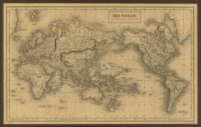
The World, on Mercator's Projection
The World on Mercator's Projection -  from the General Atlas of the World published by A & C Black in 1840


He drew a map where all curved lines on the globe, became straight lines on the map. In this way the map could show a straight line between two points that corresponded with the direction obtained by using a compass.

This map is known as “projection", where the surface of the Earth is " projected" or transferred to the surface of the maps.

On the front page of Mercator's book was a drawing of the Giant Atlas, therefore today the collection of maps is called "Atlas".